The Sign Allowance Matrix (SAM) was born out of necessity—clients consistently asked us to help them clarify how much signage they had and how much more they could add. And, more often than not, this request stems from a lease negotiation with a potential tenant who is interested in significant square footage in the building. As a design firm focusing on creating distinct brands for the built environment, specifically wayfinding programs, the alignment became a natural first step in our discovery process.
So, we thought it was important to make this a stand-alone service offering.
A SAM is typically initiated when there is a signage inquiry, as previously mentioned for a prospective tenant, or to solve a wayfinding pain point. Unless you’re one of the diligent property managers or owners, you likely don’t have an updated signage matrix on hand that clearly outlines your maximum allowable sign area (MASA). Especially given the market fluctuation over the last two years, with tenants mostly going, our clients typically don’t have this information readily available. This is why we developed the Sign Allowance Matrix.
The SAM is a detailed outline specifically for property managers and building owners who want a holistic and accurate survey of their exterior signage allowance with specific guidance on how to carefully maximize wayfinding. The goal is to achieve that careful balance of wayfinding that allows owners to maximize visibility and leasing goals with serious consideration for visual overload.
The SAM process is inclusive of the following phases and deliverables:
Phase 1: Research
During this first and very important phase we collect information from the property manager including any upcoming wayfinding plans, visibility goals and ideas. Understanding what a client is hoping to achieve through wayfinding sets us up for success when crafting our recommendations. Additionally, during this phase we collect all background documents—building elevations and any current civil engineering and site surveys. Building elevations are especially important for accurate calculations of building frontage and MASA. Of course the most critical part of the process is our research of county records both online and in person. Understanding what is allowed by permit and what is existing on record ensures accuracy of our forecast and strategic recommendations.
Phase 2: Survey
Once we’re able to uncover what’s currently on file at the county, we plan our site visit. In person, we’re able to survey existing conditions and all sign types in order to find alignment and solidify the current landscape. Often we will take additional measurements to ensure all of our findings are aligned, even though this step always uncovers signs that were never documented or permitted with the county. Beyond taking into account existing wayfinding, this step also includes a visibility study where we survey the property from various vantage points, both vehicular and pedestrian, in order to prepare an informed signage location plan.
Phase 3: Document
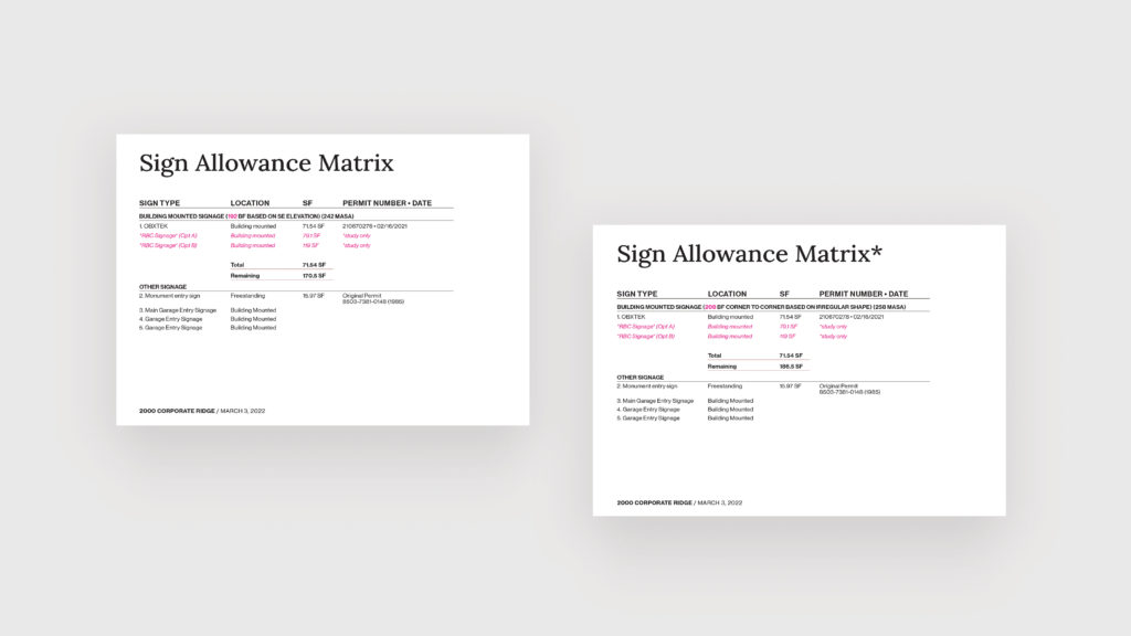
With all background and survey information in hand, we prepare a working master document that clarifies property specifics including information collected during the research and survey phases. Specifics are pulled together and visually outlined in our custom and beautifully designed SAM template. Our SAM document outlines critical property specifics including zoning and MASA as well as all research findings in alignment with parameters defined by the zoning ordinance. All of these elements are detailed in the sign matrix. The matrix itself is a table that outlines each existing sign by permit number and total SF in a visually formatted way to clearly show exactly how much signage is in use and if any remains.
Phase 4: Deliver Findings and Recommendations
The grand finale—a formal document that details existing conditions, the sign matrix and general parameters matched with recommendations specifically tailored to your property based on insight, background information and goals. A SAM provides clarity for property managers and owners allowing them to identify where they can enhance wayfinding and make more strategic decisions around tenant signage.
can help.
The SAM stand-alone service is specifically for property managers and owners who need clarity around existing and potential wayfinding opportunities. The ideal client works directly with us as the decision maker, not as another staff member to ensure we’re collecting an accurate baseline to begin our work. The SAM process typically takes 4-8 weeks to complete once all background information is received specifically building elevations and visibility goals.
Interested?
If a SAM sounds like something that would be helpful for you and your property, start by contacting us directly so we can assess your wayfinding pain points and get you the information you need to make more informed decisions.